Bass & Flinders Mapping of Tasmania
Learn about Tasmania history on an escorted small group tours for mature and senior couples and solo travellers interested in Aboriginal, wildlife and colonial history of Tasmania, Australia.
14 Dec 20 · 11 mins read

Bass and Flinders Mapping of Australia
By Marco Stojanovik
On October 7, 1798, George Bass, Matthew Flinders, and a crew of eight set sail aboard the colonial sloop Norfolk from Port Jackson bound for Van Diemen’s Land (Tasmania). Separate voyages by the two men in previous months had led them to the shared view that there exited a strait separating New Holland (mainland Australia) from Van Diemen’s Land. However, neither journey had made this conclusive.
Vice Admiral John Hunter, second governor of New South Wales, was equally intrigued by this conundrum, hoping to find a shorter passage to England. And so, in late 1798, he gave command of the Norfolk to Captain Matthew Flinders with the order to solve the question once and for all. This journey would prove a grand success, traveling the east Australian coastline and making the first circumnavigation of Tasmania, thereby proving it was an island and the existence of the Bass Strait.
This article explores the three voyages taken by Bass and Flinders leading to the discovery of the Bass strait. Much of the information is taken from chapters seven and eight of Rob Mundle’s book Flinders: The Man Who Mapped Australia.

Bass’ Whaleboat Voyage
The existence of a sea strait separating Van Diemen’s Land from New Holland was first proposed in 1797 by the master of Sydney Cove, a damaged ship that had been grounded on Preservation Island at the eastern end of the strait. While stranded here, the master of the ship, Captain Hamilton, noted that the westerly swell and the tides and currents suggested that the island was in a channel linking the Pacific and Southern Ocean.
Upon being rescued and returned to Sydney, he reported these observations, which intrigued both George Bass and Governor Hunt. This would be a significant discovery as the passage from England to Port Jackson would be shortened by some 300 nautical miles, and the ships would, more often than not, be sailing in more favourable weather conditions.
For Bass, this mystery was in need of a solution sooner rather than later, and so he proposed an expedition to find out. Governor Hunt, certain that a strait existed, needed little convincing to support the idea, quickly arranging for Bass to be provided with a whaleboat measuring about 8.5 metres in length. Sufficient provisions for a six-week voyage were put aboard and six volunteers were drawn from the ships in port at the time to form a crew for the expedition. After little more than a month preparing, on 3 December, 1797, Bass took the helm of the whaleboat and left Sydney.
Travelling down the Australian eastern coast, Bass made many landings and discoveries. His fist point of interest was a large hole of 25 to 30 feet in diameter, later to become known as the Blowhole, and the region as Kiama. Further along, he observed a pristine strip of white sound that formed a gentle arc, with a delta-like shallow entrance to a river system at its southern end – the Shoalhaven River and Heads.

Bass also reported on Jervis Bay (named previously by Lieutenant Richard Bowen, a commander of the Third Fleet, which had passed the entrance in 1791) as well as the sheltered waters of Batemans Bay. Further south, he then took the opportunity to explore inland with abated seas allowing the whaleboat to enter a shallow creek. Here he was captivated by the scenery, describing it as “one of the prettiest harbours”, and named it Barmouth Creek, later renamed Pambula. Two days later he had the good luck to also discover Twofold Bay, naming it after its two large bights.
On January 2, Bass passed Wilson’s Promontory and sighted what he believed to be some of the Furneux Group of Islands, where the crew of Sydney Cove was marooned. Initially, the wind was favourable for a course south-south-east towards the islands, but later in the day a change in wind direction brought rapidly rising seas and consequently damage to the boat. And so, the boat was forced on a course back to the north to find land.
Early the next day, land was sighted off the bow. Landing on the shore, Bass’s men patched the boat as best they could and continued to cruise along the coast to the west until, on January 4, they reached a large bay. They named this Western Port as at this stage it was the westernmost bay that had been discovered. A combination of gale winds from the south-west, and the necessity to repair the boat properly, saw them stay here for 13 days, during which Bass made a careful examination of the harbour.
By this stage Bass had been away from Port Jackson for seven weeks, a week longer than originally planned for the entire journey. And so, with a badly strained boat, diminishing provisions, and a return voyage still ahead of them, he reluctantly elected not to continue sailing west but instead trace their course home.
When Bass arrived in Sydney on February 25, 1798, the answer to whether the coastal waters were part of a strait or gulf had not been reached. Nevertheless, Bass was convinced by the tides and swells that they had been in a strait. Despite the need to still confirm this, the expedition had undoubtedly been a success, exploring more than 600 miles of the coast south of Port Jackson.
Years afterwards Flinders would reflect on his friend’s achievement: “A voyage especially undertaken for discovery in an open boat, and in which 600 miles of coast, mostly in boisterous weather, was explored, has not, perhaps its equal in maritime history.”
Flinders Sets Sail Aboard Francis
Unknown to Bass, on his voyage back to Port Jackson he had passed the colonial schooner Francis sent by Governor Hunter to the wreck of Sydney Cove to salvage the remaining men and cargo. Aboard Francis was Flinders, whose close allegiance to the governor had allowed him to join along to carry out some exploration of the Furneaux Group, where the wreck was located.
Francis left Port Jackson on 1 February, sailing down the coast as near as the shoreline as safe navigation would allow so that Flinders could confirm the location of known land features on his chart and to add new ones. The first major discovery came just two fays out of port, when Flinders sighted Montague Island, south of Batemans Bay. Then the next morning, he sighted and named another prominent feature of the south-east corner of New Holland: Cape Green. Sailing further south, they came across a previously unknown cluster of islands, which Flinders placed on his chart as the Kent Group.
On the evening of 12 February, Francis came to anchor in a well-protected stretch of water on the eastern side of Preservation Island near the sight of the wreck of Sydney Cove. A few days later, on February 16, as the crew salvaged the wreck, Flinders was provided with a small boat so that he could undertake a five-day excursion around and onto the adjacent islands. Flinders initially explored through Armstrong’s Channel, which separated two of the larger islands of the Furneaux Group, and also observed and identified a number of birds, animals and sea life including wombats, hair seals, and penguins.
On 25 February, with the remnants of the crew and cargo from Sydney Cove aboard Francis, she set sail for Port Jackson. By now, Flinders had also come to the view that a strait existed. The only thing to do was to prove the idea by sailing right round the island of Tasmania.
A Straight is Discovered
Governor Hunt, like Bass and Flinders, was almost certain that a passage existed between Van Dieman’s Land and the southern coast of New Holland, linking the Indian Ocean and the Furneaux Islands, and so without hesitation prepared a mission that would prove their theory. He commandeered the recently built Norfolk, a 10.7 metre vessel originally intended for supplies and despatches between Norfolk Island and Port Jackson, and placed it under the command of Flinders for a planned 12-week endeavour.
Flinders was given the order to sail beyond Furneaux’s Islands, and should a strait be found, to pass through it and return by the south end of Van Diemen’s Land, making examinations and surveys along the way. On 7 October, 1798, he began his journey south, along with Bass and a crew of eight. Working together brilliantly, Flinders concentrated on charting, while Bass explored the land to describe the animals, plants and geological formations encountered.
They reached the Furneaux Islands on 19 October, spending twelve days there to note the latitudes and longitudes of as many islands as possible, sketch their profiles and describe the topography, flora and fauna. From here, the logical course was to reach the north coast of Van Diemen’s Land and then cruise to the west along the hitherto unknown coastline, until they found their answer (strait or landmass).
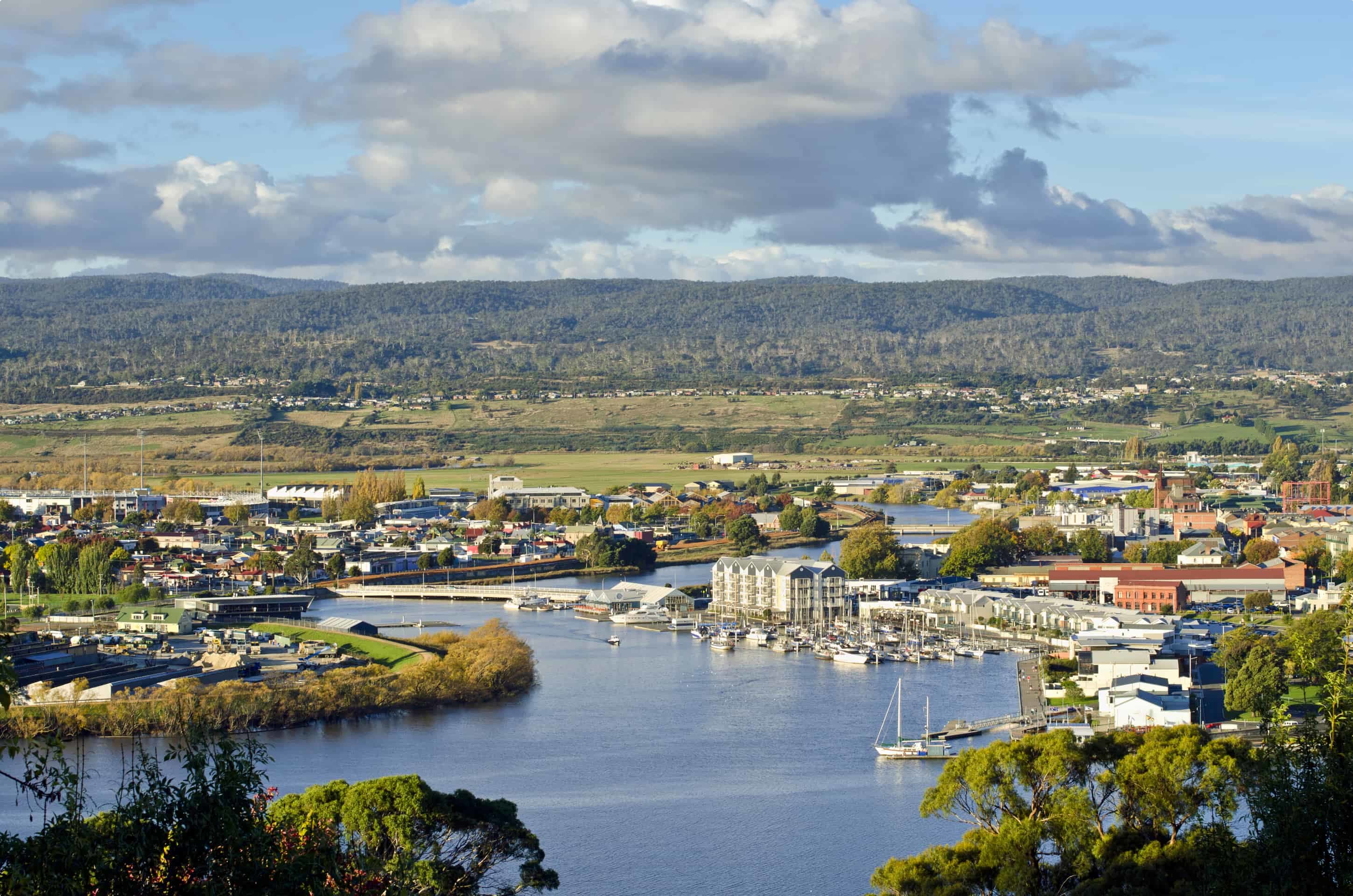
A major discovery lay in waiting: on 3 November, they entered the estuary of the Tamar River. On the banks of this river, just a few years in later in 1804, the colony’s third settlement – after Sydney and Hobart – would be established, named Patersonia, later changed to Launceston. The deeper the explorer moved upstream, the more intriguing this river became, so much so that they would spend the next 16 days exploring and the waterways and the surrounding land, charting and documenting their observations in considerable detail.
On 20 November they cleared Low Head and returned to their westerly track, only to be pushed back and holed up by gale winds and rising seas. Finally, on 3 December, they were able to weigh anchor and guide Norfolk out of the river mouth, later named Port Dalrymple by Governor Hunter, and continue sailing west along the uncharted coast.
As they sailed along, the north-west inclination caused concern that Van Diemen’s Land might be joined to the mainland. However, as they reached what they described as “three hammocks of land” (Three Hammock Island) in the north-west on 7 December, Flinders and Bass became increasingly confident they were on the verge of a history-making discovery. Flood waters coming from the west was considered a strong ground for not only the existence of a passage between this land and New Holland, but also that the entrance into the Southern Ocean could not be far distant.
On 9 December they rounded the north-east corner of the ‘three hammock land’ and pursued a course along its northern shore. Little did they known, they were only five nautical miles from the point where they could change course to the south and sail down the west coast of Van Diemen’s Land, thus revealing the existence of what would be named Bass Strait.
Only a matter of hours later, Norfolk rounded the northernmost tip of an island, which Flinders named Hunter Island in honour of the governor of the colony. Here, they were left with no doubt they had every reason to celebrate with beyond this nothing like mainland was to be seen.
From here they explored Albatross Island, and another four small islands south, the largest of them named Trefoil island because it was shaped like a clover leaf. By now, Bass and Flinders were convinced that the extended coastline they were seeing to the south was the western shore of Van Diemen’s Land – and that they were about to position a very large landmass on the world map.
Heading south they rounded the north-west cape, fittingly named Cape Grim as it appeared treacherous and uninviting, and sailed down the west coast for four days, sighting such discoveries as Mount Norfolk, then Macquarie Harbour, Mount Heemshkerk, and Mount Meehan.

By this point, Flinders, Bass, and Crew were becoming frustrated by the drawn-out monotony of the coastline they were skirting: desolate, dangerous, and far from fascinating. Relief was not too far away, however, as passing Port Davey they were closing in on a major turning point, South West Cape. Once having rounded the cape, they were fewer than 40 nautical miles before they could alter their course towards north.
Sailing along the south coast, they spent time in the south-east at Frederick Henry Bay (known today as Blackmans Bay), and Storm Bay up the Derwent River, which they reached on 21 December. Over the next nine days the men explored around 18 miles up the river to the point they could go no further, Herdsmens Cove. They went ashore on numerous occasions, and when they reached Sullivan’s Cove, where Hobart is now situated, Bass landed on the river bank and climbed the 4170 feet to the top of ‘Mount Table’ (today Mount Wellington).

On January 4 they cleared Storm Bay and continued sailing along the east coast of Van Diemen’s Land, closing on the coastline wherever possible so that Bass and Flinders could add to their ever-expanding chart, pepper with points of interest not previously known to any European. Finally, on January 9, they cleared the north-east corners of Van Diemen’s Land, and in just over twenty-four hours were rounding Cape Howe, New Holland, on their way to Port Jackson. With this came cries of celebration: they had successfully charted the island of Van Dieman’s Land, proving the existence of the strait.
Tours of Tasmania
Odyssey Traveller visits Tasmania as part of three guided tours:
- Our Small Group Tour of Flinders Island explores spectacular scenery, rugged coastline, and stunning views often in a wilderness setting. The field trips during this 9-day walking holiday allow the visitor to learn and experience the natural wonders of the islands that make up the Furneaux Group, deep in the Bass Strait. Visitors on this guided walking tour learn about the abundant wildlife, including sea lions and wildflowers, the bird life, the spectacular scenery, the amazing geology, and the fascinating, if not sometimes uncomfortable, history.
- Wildlife-rich destinations are found at regular intervals along our Wildlife Tour of Tasmania for mature and senior travellers. The aim of this tour package is to provide access to a variety of natural Tasmanian locations where wildlife can be experienced, including visiting World Heritage areas such as the Tarkine rainforest or places such as Cape Grim in the North West. We provide the opportunity to observe a variety of endemic species, combined with dramatic scenery of places like the Gordon River, Cradle Mountain, the rugged South East coast, the South West coast, and multiple National Parks. Where possible, ecosystems will be analysed in relation to the animals we see. During our learning about the wildlife of Tasmania we will also examine aspects of Tasmania’s Aboriginal and Early European history, as well as a look at the conservation history of this island state.
- Meanwhile our Colonial Tasmania Small Group Tour is especially designed for those with an interest in colonial history. Naturally, this being Tasmania, we will also travel through many areas of natural beauty, pristine wilderness, spectacular landscapes, stunning scenery and dramatic coastlines on this sightseeing tour. We partake on a a circular route that begins and ends in Hobart. After exploring the area around Hobart and the east coast, we journey north through the heart of the island, through lands settled by the early immigrants, until we reach Launceston. From Launceston we travel through the Tamar valley along the rugged coastline of the north coast, north west as far as Stanley before heading back south to the pristine wilderness, spectacular landscapes, and rugged mountains around Cradle Mountain and on through Strahan, Queenstown and past Lake St Clair, before arriving back in Hobart.
Odyssey Traveller has been serving global travellers since 1983 with educational tours of the history, culture, and architecture of our destinations designed for mature and senior travellers. We specialise in offering small group tours partnering with a local tour guide at each destination to provide a relaxed and comfortable pace and atmosphere that sets us apart from larger tour groups. Tours consist of small groups of between 6 and 12 people and are cost inclusive of all entrances, tipping and majority of meals. For more information, click here, and head to this page to make a booking.
Articles about Tasmania published by Odyssey Traveller:
- Hobart
- Flinders Island
- Cradle Mountain
- Freycinet Peninsula
- Lake Argyle
- Bruny Island
- Highlights of Australia: Dutch Tulips of Table Cape
- Franklin River
For all the articles Odyssey Traveller has published for mature aged and senior travellers, click through on this link.
External articles to assist you on your visit to Tasmania:
Related Tours
19 days
Nov, FebDiscovering Tasmania’s Wildlife
Visiting Tasmania
Small group tour of up to 15 mature and seniors travellers visiting and learning about Tasmania's wildlife and history. Visit Maria Island, Freycinet peninsula, Cradle Mountain, Strahan, Lake St Clair and Bruny Island over 16 days.
From A$13,650 AUD
View Tour
9 days
Oct, MarSmall group tour of Flinders Island
Visiting Tasmania
Explore and learn about Flinders Island on an escorted small group tour for mature and senior travellers who enjoy a walking holiday. For couples or solo travellers. We also explore Cradle Mountain and Launceston.
From A$8,150 AUD
View Tour
days
Mar, Aug, Sep, Oct, Nov +3Tours of Tasmania; exploring colonial history
Visiting Tasmania
Escorted program for couples and single travellers visiting Hobart, Launceston through the Tamar Valley along the rugged coastline of the north coast and heading back south to the pristine wilderness around Cradle Mountain and then on through Strahan, Queenstown and past Lake St Clair, before arriving back in Hobart. This 18 day small group tours to Tasmania for mature and senior travellers interested in the colonial history of Tasmania. We follow the footsteps of the colonists, visiting the churches where they worshipped, the houses in which they lived, the taverns where they drank and some of the mills in which they worked.
Articles
Cradle Mountain, Tasmania
One of Tasmania's most iconic natural wilderness destinations. Explore Cradle mountain on a seniors small group tour of Tasmania designed for active couples and solo travellers or select another iconic Australian or New Zealand tour.
Flinders Island, Tasmania
Learn more about this island in the Bass strait as you prepare for week long small group walking tour of the island that begins and ends in Launceston. For fit mature and senior travellers, couples or singles with an interest wildlife and history.

Freycinet Peninsula, Tasmania
Small group tour of the Tasmanian wilderness for senior travellers. This tour for active couples and solo travellers explores Wineglass Bay on the Freycinet Peninsula is one of the jewels of Tasmania's east coast, walking a section of the bay of fires walk and learning about Aboriginal history.

Strahan and the Gordon River, Tasmania
Learn and explore Strahan and the Gordon river on Tasmania's west coast on a small group tour for senior travellers. This 16 day is for active couples and solo travellers who seek to learn as they travel. View some of the Best tours of New Zealand and Australia.
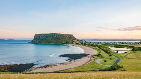
Stanley, Tasmania
Explore the sights and history of Stanley, with its historic colonial buildings and pristine natural landscape, Stanley is one of North West Tasmania's highlights. Odyssey offers small group tours for mature and senior travellers, couples, and solo travelers to Australia and Tasmania.

Launceston, advice for small group tours
Launceston, learn about this early British settlement in Tasmania on the Derwent river as well other pieces on the island state. Article supports small group tours for mature and senior travellers across Australia.
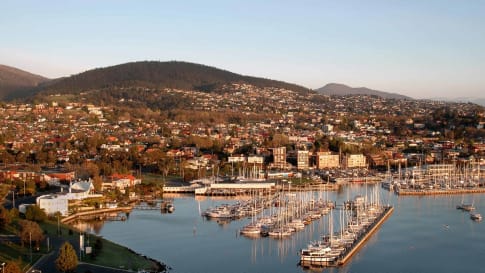
Hobart, Tasmania
Join some of many classes offered in the summer schools each January for a fortnight in this city or take a small group tour for senior and mature travelers of Tasmania wildlife & history.

Bruny Island, Tasmania
Explore the sights and history of Bruny Island, with its soaring dolomite cliffs and white sand beaches, it is home to some of Tasmania's richest natural heritage. Odyssey offers small group tours for mature and senior travellers, couples, and solo travelers to Australia and Tasmania.