


The South and East Alligator Rivers
An Antipodean travel company serving World Travellers since 1983 with small group educational tours for senior couples and mature solo travellers seeking to learn off the beaten track. The Northern Territory, famous for Uluru is more than this icon or Alice Springs and Kakadu. Read on to learn more.
The South and East Alligator Rivers
By Marco Stojanovik
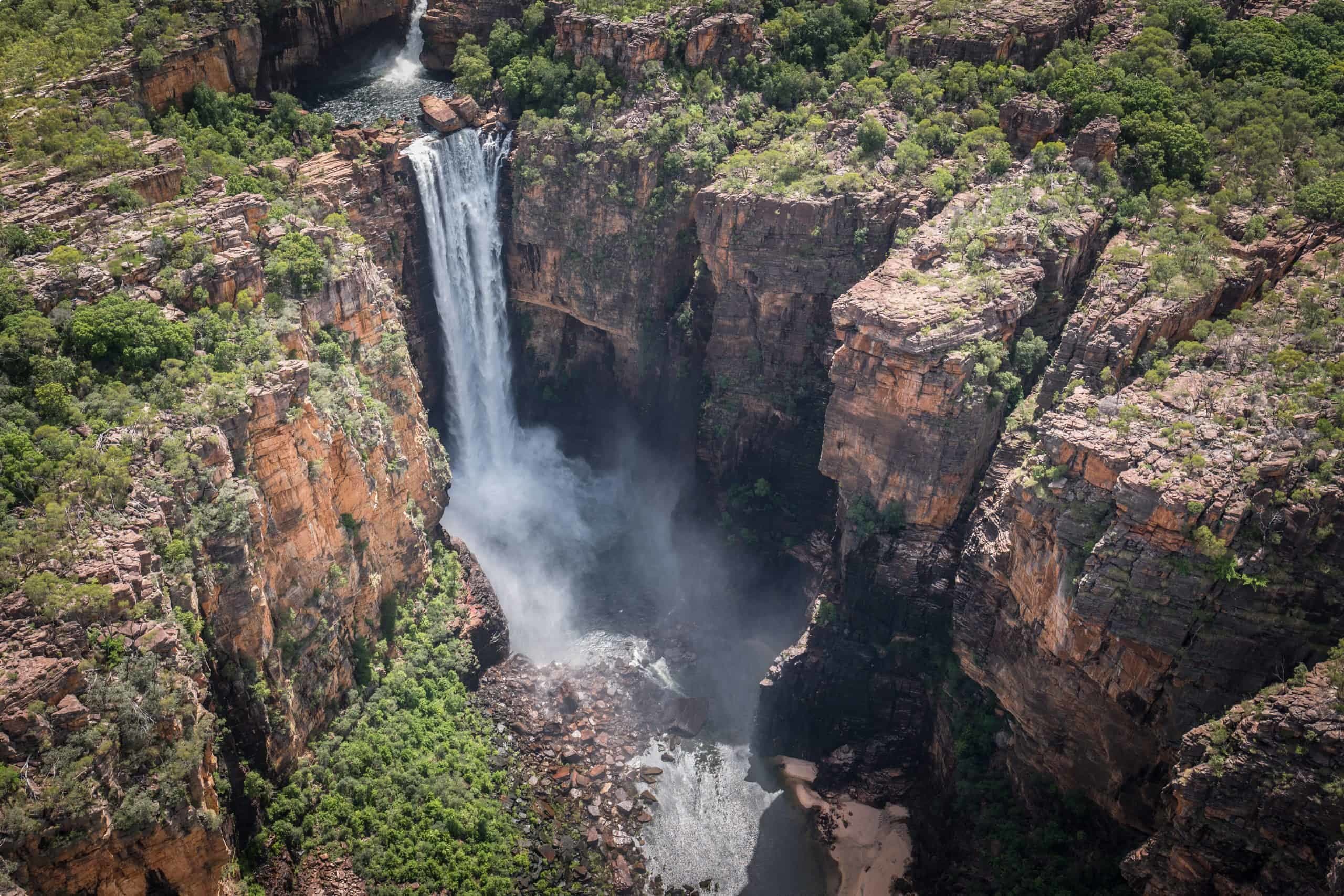
The Alligator Rivers area in the Arnhem Land region of the Northern Territory of Australia is home to some of the richest biological diversity and most stunning landscapes in the country. This is especially the case amongst its two main rivers – the East and South Alligator. Both rise in dramatic stone plateau country, some 300 metres high, which extends from Coronation Hill north-west into Arnhem Land. The red rock is around 1.6 billion years old, while the freshwater river ecosystems have developed over the last 6,000 years, since the point the sea reached its current level.
The South Alligator River rises north of Mount Stow, on the Arnhem Land Plateau, and flows northerly down through the centre of Kakadu National Park. Remnants of the river’s previous course wind through its floodplain, surrounded by billabongs and swamps, which remain wet even in the dry season. As the river narrows, it becomes more serpentine, before finally, after 160km, its wide estuarine mouth opens into the Van Diemen Gulf of the Timor Sea. Here, mangroves line the water, while a saltwater mudflat sits behind.
Rising in the northern part of the Arnhem Land Plateau, the East Alligator River flows 160km north-westerly, with approximately 60km of it forming Kakadu’s wriggling natural eastern border. It then also opens out to the Van Diemen Gulf at Point Farewell, as a wide, mangrove-lined mouth. Closer to its source, the river is lined with pandanus, beach hibiscus and three types of paperbarks: the weeping, the silver-leaved and the broad-leaved.
For over 60, 000 years, the Bininj and Mungguy people have shaped the land around these rivers, managing the natural environment and recording their history and spirituality in thousands of rock art sites. The European presence over the last 200 years has been tumultuous for the traditional custodians of this land, but their ownership is now recognised through Native Title and the management of Kakadu National Park.
This article is intended as background information for your tour of the Alligator Rivers. It goes on to explore the rivers’ shared wildlife and Aboriginal and European history. Odyssey Traveller visits the East and South Alligator Rivers as part of our 14-day Darwin and Kakadu small group tour.
Much of the information used in this article has been gathered from Ian Hoskin’s book Rivers.


Wildlife on the Rivers
The Alligator Rivers sustain a rich and diverse range of iconic animals. Perhaps most notable are the many crocodiles lying around the banks on the lower reaches of the rivers. Females lie every 50 metres or so in a stretch of river defended by a highly territorial, dominant male.
It is from these crocodiles that the rivers take their name. Although separate species, it is likely that the names ‘alligators’ and ‘crocodiles’ were used interchangeably when Europeans were exploring their new worlds.
Today there may be even more crocodiles than in the past, with an estimated 10,000 across Kakadu. They have recovered remarkably since being declared a protected species in the 1970s, after having been driven to the brink of local extinction by extensive commercial hunting and blood sport.
Both freshwater (‘freshies’) and saltwater (‘salties’) crocodiles can be found the in rivers. Both are regarded as dangerous and should never be approached. The most dangerous of the two are the salties. The largest living reptiles in the world, they grow up to five to seven metres in length and 1000kg. They are known to take humans, wild pigs, buffaloes, and livestock such as cattle and horses.


Forty-six species of fish can also be found in the river system, representing about a quarter of all known species in Australia. One type of fish is particularly associated with these waterways: the barramundi. The ‘barra’ is a large and favourite food source, which sustained the first river people and attracted the sport fishers who followed.
Birdlife is also prolific, with over one in three of Australia’s species having been sighted in the region. In particular, magpie geese, the much smaller green pygmy goose, and the radjah shelduck only occur at this continental Top End. In total, the Alligators Rivers floodplains is estimated to support some five million water birds.


In the relatively shot occupation by Europeans, a number of species have also been introduced to the area. Domestic cats and wild pigs flourish, while invasive species such as feral water buffalo and cane toads are also causing problems.
Aboriginal Culture
Kakadu is believed to be one of the first areas settled by humans in Australia over 70,000 years ago. Continuously, over an extraordinary length of time, people have lived in this place, adapting to successive environments in which the Alligator Rivers are relatively recent elements.
Recent excavations nearby the Alligator Rivers in a rockshelter at Madjedbebe revealed tools that are 65,000 years old, challenging prior scientific consensus that Aboriginal people only arrived in Australia 47,000 years ago. The archaeologists uncovered more than 10,000 stone artefacts, including stone axes, seed-grinding tools, stone points (likely used as spear tips), and ochre. The stone axes found here are likely the oldest ground-edge stone axe technology in the world.


The traditional owners in this part of the Northern Territory are known collectively as Bininj and Mungguy. The Bininj are from the northern part of Kakadu and the Mungguy in the south. The Bininj/Mungguy people further divided into around 19 clans, or family groups sharing ownership of an area of land. Clan boundaries are passed from one generation to the next, mostly through the father.
The Bininj/Mungguy understand the landscape as left by the Creation Ancestors in the Creation Time, who also laid down rules to live by, teaching Aboriginal people how to live with the land, before turning into djang (dreaming places). The East Alligator River itself is understood to have been created during the Creation Time by a barramundi called Ganbarra’gardi as he escaped attack in his home on the rock plateau.
The Rainbow Serpent is also an important part of Bininj/Mungguy spirituality. Rainbow Serpents are found in the beliefs of Aboriginal people around Australia and are believed to be one of the oldest artistic symbols used in the world. For the Bininj/Mungguy, the Rainbow Serpent was an all-powerful ‘boss lady’ who rested in quiet waterways unless disturbed – in which case she was capable of causing serious natural disasters including floods and earthquakes.
The Rainbow Serpent is said to have taken on a human form and painted her image on the rock at Ubirr to remind people of her presence. She then rested in the forest at Manngarre, before crossing the East Alligator River into Arnhem Land, where she lives in a quiet water hole.


The rock art site at Ubirr, a plateau ‘outlier’ located near the East Alligator River, is considered to be one of the finest collections of ancient rock art in the world, some paintings dating back 20,000 years. Groups of people traditionally camped under the cool rock shelter and exploited the rich resources of the surrounding river and floodplain. Over millennia, they painted and re-painted the smooth rock surfaces.
The main gallery at Ubirr is home to an extensive collection of x-ray art from the freshwater period, mostly depicting fish, turtles, goanna, and other important food sources. The main gallery also contains a fascinating specimen of contact art, a ‘white fella’ shown wearing a shirt and boots, with his hands in his pockets, likely a buffalo hunter painted in the 1880s. Stories about law are told here in the Mabuyu, Narmarrkan Sisters, and Rainbow Serpent paintings (the most sacred site at Ubirr).


There is also art on the rocks along the East Alligator waterway itself, replete with images of fish with x-ray-like lines. Conceivably, they date back to the evolutions of the estuaries and rivers that are there today – 2,000 to 6,000 years ago – and are evidence of human habitation in a contemporary freshwater environment.
European Presence
The explorer Phillip Parker King was the first English navigator to enter the Gulf of Carpentaria. Between 1818 and 1822, he conducted a number of explorations in the area, which he called Arnhem Land (the name given to it by homesick Dutch who passed by in the 17th century). It was King who named the rivers after the crocodiles which he mistook for alligators.
At this point the rivers and the land around them were outside the west boundary of the colony of New South Wales (NSW) and were yet to be claimed by any external power. That changed in 1825, when the western boundary of NSW was shifted from 145° to 129° longitude. What is today the Northern Territory remained part of the colony until 1863, at which point South Australia annexed it for itself. The still young Commonwealth of Australia then assumed control of the Territory in 1910.
The European presence brought upon a slow but escalating impact on the Bininj and Mungguy people. From 1891 to 1980 the population of traditional owners around the rivers declined from an estimated 980 to just 111. Several groups were simply wiped out.
The new Commonwealth regime sent the biologist, anthropologist, and administrator Walter Baldwin Spencer to the tropical north in 1910 to gauge the impact. He was to report upon and then ‘protect’ the Territory’s Indigenous population as Chief Protectors of Aborigines. While there he observed the rapidly dissipating effects of ‘white’ civilisation with its alcohol, prostitution, and disease.
His observations led him to suggest in 1912 that a reserve be established to protect Aboriginal people from the Mary River in the west to the head of the South Alligator and east of the Liverpool River. It was to be called the ‘Alligator Rivers Reserve’.
The creation of the Woolwonga Aboriginal Reserve followed in 1936, including a substantial section of the South Alligator River and its eastern flood plain. Its purpose was to accommodate people displaced from an area of interest to miners in the west. Small-scale gold mining had started in the region in the 1920s at Imarlkba near Barramundi Creek and continued at Moline in the 1930s.
It was the discovery of uranium at the headlands of the South Alligator River in 1953 though that really started the mining industries in the area. Thirteen uranium mines were operating by 1957, employing 150 people.


The Struggle for Aboriginal Ownership
Since the mid-20th century there have been moves made to protect the unique natural environment of the Alligator Rivers region from the disruptions of mine and pastoral leases. From 1964, the Woolwonga Aboriginal Reserve conveniently doubled as a wildlife sanctuary. Then the Aboriginal Land Rights (Northern Territory) Act 1976 recognised Aboriginal Rights to existing reserves, such as Woolwonga, and allowed for claims to other Crown Land.
The passage of the Act coincided with an investigation into the impact on Aboriginal society of a proposed mining operation between the two rivers: the 1977 Ranger Uranium Environmental Inquiry (Fox Report).
The Fox Report expressed concern for the welfare and interests of the Aboriginal people impacted by the influx of a large European population to the Alligator Rivers Region. It concluded that firm measures be taken to ensure that the Aboriginal people remain sufficiently isolated and able to live according to their own lifestyles on their own land, without intrusion or interference from others. As such, it recommended acknowledgement of Aboriginal title to a substantial part of the region and the establishment of a national park.
As a result of the report’s recommendations, Aboriginal people regained ownership of two parcels of land, which included parts of the upper South Alligator and the lower East Alligator rivers. This was the first recognition in Australia of a traditional claim to Crown land outside Aboriginal reserves. A lease between the newly formed Kakadu Aboriginal Land trust and the Commonwealth Director of National Parks and Wildlife was then signed in 1978, paving the way for the creation of Kakadu National Park the following year.


The national park was then listed as a UNESCO World Heritage Site in 1981, one of the first in Australia. It is one of only four places in Australia inscribed for both cultural and natural values, recognised as ‘a living cultural landscape with exceptional natural and cultural values’. In particular, UNESCO singled out the artistic achievement and historical value of Kakadu’s collection of Aboriginal art.
Subsequent successful Aboriginal land claims have led to an extension of the park, so that it now encompasses all of the South Alligator River and its catchment and much of the East Alligator. Traditional owners continue to contribute their knowledge through the process of creating, expanding and managing the park.
Tour of the Alligator Rivers
Odyssey Traveller visits the South and East Alligator Rivers as part of our new tour of Kakadu and the Northern Territory. Beginning and ending in Darwin, our tour is designed to go beyond the highlights of your typical Kakadu Day Tour, our trip spends six nights in comfortable lodge accommodation in Jabiru, allowing you to make the most of your Kakadu tour.
Kakadu is Australia‘s largest national park and a place of vast and varied ecosystems, ranging from rugged escarpments to tidal flats. We explore the natural beauty of the park – sandstone escarpments, monsoon forest, and the stunning waterfalls of the Gunlom Plunge Pool and Waterfall Creek.
Kakadu park is also home to a vast array of native wildlife, including the most threatened species protected in any Australian reserve. We also walk among the RAMSAR-listed Kakadu wetland, seeing rare bird species; and learn more about wildlife on a Yellow Water Cruise of the Yellow Water Billabong, including the saltwater crocodile in its natural environment! And of course, we leave plenty of time to walk among the ancient Aboriginal rock art of this extraordinary park, while learning about Aboriginal land management from local Indigenous people.
Our tour of Kakadu also explores the surrounding areas of the Northern Australia. We will spend a couple of nights in Arnhem Land, a centre of indigenous culture and a place of great natural beauty. On our way along the Stuart Highway to Kakadu we make several side trips, to the Fogg River Conservation Reserve in the Mary River Wetlands, and to Litchfield National Park, where our Litchfield tour takes in striking termite mounds and the pristine Buley Rockhole, one of the Northern Territory‘s most popular swimming holes. We will also make a trip into Arnhem Land, a stronghold of Aboriginal culture and a place of great natural beauty.
Our tour price includes lodge accommodation, transport in suitable vehicles, and meals, including breakfasts, a group dinner, and picnic lunch. For more information, click here, and click here for more on our outback and Australia tours.

Articles about Australia published by Odyssey Traveller:
- Aboriginal history and culture of Kakadu National Park, Northern Territory
- The Kimberley: A Definitive Guide
- Uncovering the Ancient History of Aboriginal Australia
- Aboriginal Land Use in the Mallee
- Understanding Aboriginal Aquaculture
- Mallee and Mulga: Two Iconic and Typically Inland Australian Plant Communities (By Dr. Sandy Scott).
- The Australian Outback: A Definitive Guide
For all the articles Odyssey Traveller has published for mature aged and senior travellers, click through on this link.