

An introduction to Chile
Santiago de Chile is the capital of a nation of nearly 17 million people. It occupies an area of 756k square kilometres. Although Chile is derived from a local indigenous word meaning ‘cold’, that description only applies to the extreme south. Chile has the largest latitudinal spread of any of the South American nations – from 17ºS to 55ºS: a distance of 4,222 kilometres. The country is never more than 180 kilometres wide. There are three distinct zones – north, central and south. The north is a coastal desert with very valuable mineral deposits of nitrates and copper. The central region has a pleasant Mediterranean-type climate and has intensive agriculture. This is the most densely populated region and includes both Santiago and Valparaiso. The southern region has a cool temperate climate, is sparsely populated and has large rainforest areas. The Andes form the boundary with Argentina.
A brief history of Chile
The Araucanian Indians were the original inhabitants of Chile. The Spaniards conquered most of the area during the 16th century, although the Araucanian people continued to resist in the remote south. Chile eventually won its Independence from Spain in 1818 after battles led by San Martin and Bernard O’Higgins. The population is of predominantly Spanish descent with a mixture of Scottish, Irish, English, Welsh and Italian influences. Names like MacKenna, O’Higgins, Cochrane, Edwards and Alesandri are revered names in Chilean revolutionary history.
Chilean civil war
Today, Chile is a republic with a president and a legislature. A civil war broke out in 1891 and a parliamentary system of government was established. In 1970 a Marxist, Dr Salvador Allende, led the Unidad Popular Party to power. In 1973, a military coup led by General Augusto Pinochet Ugarte seized power and President Allende was killed during the fighting. Pinochet and the military junta ruled Chile with an iron fist from 1973 to 1990 and all dissent was ruthlessly suppressed. Thousands of people vanished during this period at the hands of the military. Thousands of Chileans sought refuge in other countries, including Australia.
A period of recovery in Chile
During the 1980s, the military decided that communism was no longer a threat and gradually relaxed controls until allowing a presidential election in December 1989. Pinochet formally relinquished control in March 1990 but remained in command of the army. Chile now has a strong parliamentary government and is recovering from the excesses of 1973 – 1990. Australian companies are major investors in Chile, particularly in minerals. The National Congress meeting place has been moved from Santiago to Valparaiso, partly to break with the turbulent recent past, but also to encourage development in Valparaiso and ease the congestion and dominance of Santiago.


Santiago: Chile’s charming capital
Santiago is the capital of Chile. The city has a population of over five million people, the largest in the country and the fourth largest city in the continent. Santiago is a very ‘European’ city with wide streets and classic architecture. In Santiago there is a saying that ‘the nicest thing about the city is that it is easy to get away from’. But don’t let this deter you! It refers to the fact that one of the finest skiing resorts in the world is located just fifty kilometres to the east. And to the west, the port city of Valparaiso and the adjacent Vina del Mar resort city.
Atmospheric pollution is severe in Santiago as the city lies in a north-south valley between the coastal ranges and the Andes. The mountains block the prevailing winds from the west. But conditions permitting, San Cristobal Hill should provide panoramic views of this great city. Other highlights of Santiago include the Civic Centre and the Pre-Colombian Art Museum. Learn more about travel in Chile here.
Discovering Peru
Statistics of climate, population, production or area cannot do justice to South America, and certainly not to Peru. Peru is spectacular in its contrasts – contrasts within its own borders, contrasts with other regions of the great South American continent, and contrasts with parts of the world which may be more familiar to us as travellers.
Today, Peru has an area of 1.3 million square kilometres and a population exceeding 31 million people. Lima is the capital with a population of 10 million. Nearly 90% of the population is stated to be Roman Catholic. The population has developed a unique blend of the indigenous pre-Spanish worship of Pachamama and Christianity.
From Incas to Independent Peru
The indigenous Inca civilisation of what is now Peru was conquered by Spain in the early 16th century. The city of Lima was founded in 1535 and became the effective capital of the vice-royalty of Peru, established seven years later. Spain ruled the country until the early 19th century using the rich silver resources to finance its costly imperialist struggles with France, England and The Netherlands. The wars of independence, which expelled the Spanish from virtually the entire South American continent, reached Peru in the early 1820s. After the 1821 declaration of independence, Peru was challenged by the royalists. The new Government appealed to the revolutionary leader Simon Bolivar for assistance. Arriving from Colombia, Bolivar defeated the royalists at the Battle for Ayacucho in December 1824, after which he became head of state.
Peru and its neighbours
Relations between Peru and its neighbours were difficult in the early years of independence. There were border disputes with Brazil, Chile and Ecuador (which have not been settled to this day). The War of the Pacific broke out between Chile and Peru which was supported by Bolivia in 1879. It ended after five years with a complete victory for Chile and the loss to Peru of some southern territories, and to Bolivia of its strip of land with access to the coast and its seaport of Arica. Peru has always been politically unstable, experiencing a number of military coups from 1914.
Right-wing governments ruled between 1963-67 and 1980-85. In 1985 President Alan Garcia came to office with the country in political and economic turmoil. Garcia suspended payment of Peru’s massive foreign debt as a means of stabilising the country.
Pedro Pablo Kuczynski was Peru’s president up until 23 March 2018, when he abruptly announced his resignation. Kuczynski’s vice president, Martin Vizcarra, succeeded him as 67th President.


Lima: a city of extremes
Lima, on the barren coast of Peru, was the centre of the Spanish Vice-Royalty for several centuries following the conquest of Francisco Pizarro and his followers. Its influence extended throughout the Andes and the west coast of the continent until its decline with the independence movements of the late 18th and early 19th centuries.
Lima is built on a grid pattern. The centre of the city is characterised by the Plaza de Armas, the traditional city square of Spain. It is flanked by the Cathedral, Cabildo (Town Hall) and Presidential Palace. Many older colonial buildings still have the Moorish wooden-shuttered balconies. However, comparatively few colonial buildings survive as a result of earthquakes and rebuilding projects undertaken earlier this century.
Lima is surrounded by many shantytowns that attest the country’s severe economic issues. Built along dry riverbanks and the barren hillsides, they are mostly occupied by the thousands of Andean Indians who have migrated to the city in search of a better life. Few have found it, and their abject poverty contrasts with the more affluent suburbs of Lima and the nearby coastal suburb of Miraflores.

Cool and crisp Cuzco
On arrival at Cuzco you will notice the air is cool and crisp and you may feel exhilarated and light-headed. This is because of the high altitude, at 3399m. For those not used to the conditions, it is important to move slowly and restrict physical activity after arrival. In fact, it is advisable to move to a lower altitude at first, to enable yourself to acclimate. Sacred Valley is located at about 1800 metres, making it a great base from which to adjust. It can be reached via Camilid Farm, where you can experience llamas and alpacas close up and personal. You can also witness weaving done in the traditional manner, carried out by women seated on the ground using a frame to hold the threads. For more advice on altitude sickness, and other tips for active travel, check out our article on walking tours.


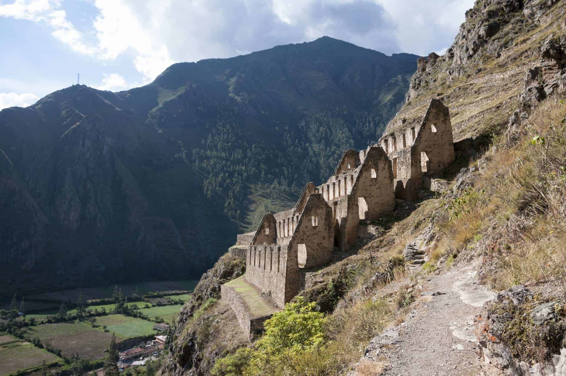
Inca ruins at Ollantaytambo
Ollantaytambo, at 2792m elevation, is a village in Sacred Valley. Nestled amid snow-capped mountains, it is home to impressive Inca ruins. Climb the Terraces to the unfinished temple and fortress overlooking the valley and marvel at the precise stone masonry and huge blocks of stone carried from nearby quarries. This is the oldest continuously occupied settlement in the Americas. One can get an idea of the brazen task facing the Spanish Conquistadors — they fought their way here from Cuzco and were met with a hostile Inca Army of thousands staunchly defending their territory. who wished to conquer this site when they first fought their way to it from Cusco many miles to the north and which was defended by a hostile Inca Army of many thousands.

Machu Picchu
How fortunate for the world that the Spaniards never discovered the location of the fabulous jungle city of Machu Picchu. Had they reached it, they would have surely destroyed it as they did other Inca settlements. It was left to Hiram Bingham of Yale University to re-discover this archaeological treasure in 1911. No description of the “lost city” of Machu Picchu can do it justice. Today we can explore it in comfort and marvel at the civilisation which it represents. Even today, surrounding areas of ruins remain to be cleared of their protective jungle cover. To understand more about why Machu Picchu is among the world’s favourite UNESCO Heritage sites, click here.
A great way to experience the journey to and from Machu Picchu is by rail. As the intensively cultivated wide valleys finally give way to the steep tropical river valley where cultivation is impossible, the train clings to its narrow track hewn out of solid granite beside the river. It affords views of the Andes which will never be forgotten. A similarly exhilarating rail journey can be made from Cuzco to Puno on Lake Titicaca. This ten hour plus experience is now operated by the Orient Express.

Lake Titicaca, Peru
The legendary birthplace of the Incas is the highest navigable lake in the world. Lake Titicaca has an area of approximately 8,300 square kilometres. It is 147 kilometres long and 78 kilometres wide at its widest point, and the water is up to 270 metres deep. Some of the challenges for Peru are typified by the old steamers which sailed between Puno in Peru and Guagui in Bolivia. These ferries were built in Scotland in the 1890s, sailed to the Pacific coast, were dismantled and carried by donkey teams to the altiplano and reassembled on site. It is not difficult to appreciate the determination of engineers!
An introduction to Bolivia
It is not every freedom fighter whose name is commemorated by an entire country, but such is the tribute paid to Simon Bolivar, one of two revered liberators of the South American continent from Spanish rule. In case the visitor would forget the Liberator, the local currency is the Boliviano. Bolivia was carved from the former Spanish Vice-Royalty of Peru. Its original borders have shrunk and the present territory has an area of 1.1m square kilometres and a population of almost 11 million, mainly Quechuans and Aymará people.
Bolivia is the poorest economy in South America and has recently suffered serious political and social unrest again. This is due in part to the very low wages paid to teachers and other government employees, high petrol prices and the loss of income by farmers in the Yungas with the prohibition on growing cocaine.
Bolivia’s geography
Bolivia has two distinct regions
- the Altiplano, including the Andes Mountains in the west and east, and
- the Yungas, which are the tropical lowlands and part of the upper Amazon Basin.
Most of the population lives on the Altiplano near La Paz, but the Yungas region is developing rapidly with commercial cattle, sugar and other crop farming (not to mention some cocaine!) Natural gas has also been found on the lowlands. The pre-historic Tiwanaku civilisation once occupied the region around the southern shores of Lake Titicaca and was later inhabited by the Aymará civilisation. In time, this civilisation was conquered by the Incas, who were themselves conquered by the Spanish in 1538. In colonial history it was known as Upper Peru.


Recent timeline of Bolivia
In 1825 Simon Bolivar led the country to independence. But wars with neighbouring countries Peru and Chile (the 1879 – 1883 War of the Pacific) lost Bolivia the strip of land leading to the coast. In 1928 Bolivia went to war with Paraguay.
In 1953 Chile declared the port of Arica ‘free’ and has allowed Bolivia certain privileges in its use. But the issue was never fully settled and bilateral relations deteriorated over the next two decades until diplomatic relations were broken in 1978. The signing of a bilateral agreement in 1986 pledging to improve political, social and economic links seemed to offer the basis for agreement. Despite pressure from the Organisation of American States to allow Bolivia unimpeded access to the sea, Chile has refused to yield on the Pacific access question.
In 1992, Peru finally agreed to allow Bolivia free use of the port of Ilo for 100 years. Bolivia, meanwhile, entered into an unprecedented era of political stability, bringing to an end a record of military coups and recurrent internal strife. There had been 192 coups in the 156 years from its independence between 1825 and 1981 – an average of one every ten months.
Political climate in Bolivia
Bolivia has been governed by democratically elected governments since 1982. In August 1985, President Victor Paz Estenssoro was elected as the head of a loose coalition of both left- and right-wing parties and inherited rampant hyperinflation (at an estimated 14,000% in 1985)

By the time he ceded office in August 1989 to Jaime Paz Zamora, inflation had been dramatically cut and, after initial unrest over the Government’s strict austerity program, the country acquired a measure of political stability. In August 1993 Paz Zamora gave way to Gonzalo Sanchez de Lozad. He was the candidate of the Movimento Nacional Recolucionario (MNR), the dominant party in contemporary Bolivian politics which, in coalition with two other parties, controlled the Congress.
The main issue at the polls was the Government’s collaboration in the US-sponsored ‘war on drugs’ in Latin America – a key feature of the Bush administration’s South American foreign policy. The government was obliged to participate with the US at the risk of forfeiting essential economic aid. This policy was deeply unpopular with ordinary Bolivians.
The President of Bolivia
The current President of Bolivia is Evo Morales, who is widely considered the first indigenous Bolivian to serve as head of state. Morales has served as President since 2006, and the focus of his administration has been poverty reduction and combating the influence of the United States and multinational corporations in Bolivia. His policies are leftist, and he is head of the Movement for Socialism party. He has been lauded as a champion for indigenous rights and environmentalism, and his contribution to the reduction of poverty is widely praised. He is criticised by some leftist critics, however, for allegedly failing to live up to his espoused values. And on the other side, criticised by the right for being excessively radical and authoritarian.


Soaring La Paz
La Paz is the world’s highest capital, and its largest city at an elevation of more than 3,500 metres. It is one of the most spectacularly-situated cities in the world and is Bolivia’s political capital. The city of Sucre, however, is the legal capital and the seat of the Supreme Court.
La Paz (meaning “the peace”) may be a misnomer, for it has been the scene of many, mainly bloodless revolutions as one junta has seized power from another in succession. The city lies huddled in a great canyon etched by water into the soft surface of the Altiplano glacio-alluvial basins. The site offers some protection from the worst rigours of the high Andean winters, when snow covers the Altiplano.
La Paz also reverses the usual rule where the wealthy occupy the highest land and the poor the lowest. For here, the effects of high altitude mean the Europeans favour the lower altitudes, leaving the higher slopes to the indigenous people. Words cannot adequately describe the first sight of this city from the rim of the canyon, before descending into it along the new freeway (which mercifully replaces the older tortuous highway!)
A lunar landscape around La Paz
The spectacular effects of water erosion are strikingly evident in the natural formations of the Valley of the Moon in the lower reaches of the canyon. The ‘lunar’ landscape is the result of heavy run-off of water over almost unprotected sediments. This follows violent thunderstorms which are a feature of the Andes and the Altiplano. It is not difficult to imagine the devastation which sometimes follows the collapse of whole hillsides of the canyon. These are districts where indigenous squatters have built adobé huts.
If La Paz is the world’s highest capital, El Alto is the world’s highest commercial airport. The airport is located on the Altiplano near the edge of the La Paz Canyon. The low air pressure necessitates a very long runway and significant restrictions on maximum take-off weights of aircraft. Aircraft have a noticeably long take-off distance and flaps are set for a very slow rate of climb.

Tiwanaku archaeological site
Tiwanaku is a pre-Columbian archaeological site located in Western Bolivia, on the southern shore of Lake Titicaca. Though it is not quite Machu Picchu in stature, its carved archways and arcades will nonetheless appeal to those interested in archaeology and history. In fact much about Tiwanaku remains a mystery. It is thought to have been inhabited from as early as 1500 BC, and experts believe its ancient inhabitants spoke Puquina – a language that is now extinct.
Odyssey Traveller tours of South America
On Odyssey Traveller’s small group tour of South America, participants will be introduced to spectacular contrasts in the physical and climatic geography that provide the setting for major contrasts in human cultures, both historical and contemporary. Our journey incorporates the study of the major archaeological sites and museums of the Tiahuanaco, Moché, Chimu and Inca pre-Columbian civilisations, together with visits to Spanish and Portuguese colonial-era cities and towns. The subsistence economies of the altiplano villages will be contrasted with large modern urban centres. We will experience the cultures of the Andean peoples with their dances and music as a contrast to the stylised Brazilian samba and the Argentine tango. If you are passionate about learning while you travel, you will find a variety of opportunities with Odyssey Traveller. If you have a keen interest in archaeology, Odyssey Traveller offers further specialised tours. Alternatively, you may be inspired by this colonial-era architecture to explore Spain and Portugal, too! As long as you remain inquisitive, we continue to design tours to challenge and excite.
About Odyssey Traveller


Odyssey Traveller is committed to charitable activities that support the environment and cultural development of Australian and New Zealand communities. Accordingly, we are pleased to announce that since 2012, Odyssey has been awarding $10,000 Equity & Merit Cash Scholarships each year. We award scholarships on the basis of academic performance and demonstrated financial need. We award at least one scholarship per year. We’re supported through our educational travel programs, and your participation helps Odyssey achieve its goals.
For more information on Odyssey Traveller and our educational small group tours, visit our website. Alternatively, please call or send an email. We’d love to hear from you!